
This story is excerpted from Eddee Daniel’s latest book, The Milwaukee River Greenway: A Wealth of Nature in the Heart of the City, published in July by the River Revitalization Foundation after Daniel’s year as artist-in-residence at the Greenway. Look for it at bookbaby.com.
I learned to love the Milwaukee River Greenway long before it was identified as such – and before it became the popular destination it is today. I have always been a lover of unkempt nature, so when I moved to Milwaukee in 1977, I was immediately, almost instinctively, drawn to it.
That this park-wrapped stretch of the city’s namesake river seemed completely wild only increased its appeal. Eventually I would come to know this urban wilderness’ history of neglect, and the illicit activities that were conducted there at the time. Wandering its crude trails felt like discovering a place of mystery and adventure.
Today the 878-acre Greenway – known as Minowakii-ziibi-ozhawaashko-miikan in Ojibwe – is less overtly wild, more welcoming. But the changes, though palpable, are far less significant than what has remained the same. It almost seems like a miracle that the bluffs are not lined with houses, apartments and condos overlooking the river; that commercial establishments devoted to waterside recreation have not cropped up on the riverbanks like they did a hundred years ago – like they have south of the Greenway.
But it is not a miracle.
The Milwaukee River Greenway is a natural haven in the bustling city because of considerable effort and planning.
The city of Milwaukee owes its existence to its rivers. Indigenous villages gathered on the bluffs surrounding the bountiful estuary. Although the harbor, which gave access to Lake Michigan and points east, was the initial draw for Europeans, the budding settler community faced inland, embracing the rivers that fed into it. A mighty industrial city grew around the confluence of the Menomonee, Kinnickinnic and Milwaukee rivers. Their banks were quickly enveloped in factories, businesses and eventually, even skyscrapers. Like cities throughout the country, Milwaukee expanded outward from this center at a steady pace; dense urban neighborhoods organized in a typical grid of streets – except for a ribbon of green space slicing an organic swath through this orderly urban geometry.

Tell us who you’d pick to be a Betty this year!
Thanks to the enlightened leadership of Charles B. Whitnall and others in the early 20th century, Milwaukee established a remarkable and enviable park system, organized primarily along its waterways. These parks were not conceived as separate, isolated places but as a beautiful necklace of interlinked spaces that transcended municipal bound-aries. One of the jewels of this “emerald necklace” has always been what is now officially called the Milwaukee River Greenway.
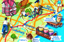
The Greenway is a nearly 8-mile, 878-acre section of the Milwaukee River that begins at the former North Avenue Dam and ends at Silver Spring Drive, cutting through the northeast side of the city and the suburbs of Shorewood and Glendale. The Greenway is wide and expansive at its northern end, narrowing at its southern end to a steep-walled valley, which together provide a unique natural setting surrounded by compact, densely populated neighborhoods. Few cities in the nation or even the world can boast of such a wealth of nature – wetlands, woodlands and deep river valley – in such close proximity to its urban core.
In what other city can you step off the street grid directly into a river valley where you are literally immersed in nature, with few cues to remind you of the urban surroundings you just left – a place where you can imagine yourself far, far away? We can do that here.
But the urban setting is also an existential threat, and in 2006 a group of stakeholders formed the Milwaukee River Greenway Coalition to oversee efforts to protect and enhance the Greenway’s ecological and recreational value. It developed a master plan guiding preservation, recreation and access, rehabilitation and
development. In what is perhaps the most remarkable accomplishment related to the Greenway, the municipalities have agreed to use zoning to protect what is known as the “viewshed” – the very experience of being in nature, including outstanding river or trail views, overlooks and areas of exceptional beauty.
No, it is not a miracle. But for the vigilance and perseverance of visionary individuals, dedicated organizations and broad-minded community leaders there would be no Greenway.
Voices of the River

Sierra Taliaferro, freelance naturalist
When I step onto the West Bank Trail at Capitol Drive, I extend my gratitude to the hands and minds who designed it for nature lovers like me to enjoy. It brings me pleasure to share this space with relatives that bless us with their presence – both plants and animals. A gentle reminder that we coexist on this land, not one species dominating the other, but simply living together. Nature is healing, it is abundant, and it is all around us. When I’m hiking or birding, I am reminded of not only the beauty around me, but the beauty within me, because nature is a reflection of ourselves.
Nature is so important for the vitality of our spirits. I hope you find your grounding in nature to maintain your joy, wherever it leads you. May you find your own pocket of paradise among the woodlands, along the Milwaukee River surrounded by elders – a symphony of plants and animals – and that you be reminded that you are never too far from an outdoor adventure in this urban oasis.
Gems of the Greenway: Lincoln Park
In 1907, with the population of Milwaukee expanding outward, the city acquired two large farmland tracts to create a large park bisected by the Milwaukee River. Originally called Evergreen Park, the name was changed in 1916. A six-hole golf course was developed and later expanded to its current nine holes, and a bridge built at Hampton Avenue to connect the two sides.
But the meddling with the river that had gone on apace since the first dam was built a century prior reached a kind of apotheosis at Lincoln Park.

In the 1930s, as America desperately tried to build its way out of the Great Depression, the Civilian Conservation Corps and Works Progress Administration embarked on a project that would become one of the largest CCC endeavors in Milwaukee County: changing the course of the Milwaukee River. A large S-curve in the river had been causing ice jams and floods every spring. Digging almost entirely by hand, nearly 2,000 workers not only relocated the river but also constructed four islands and a large lagoon flooded by a companion CCC project downstream: the Estabrook Dam. The Milwaukee River Parkway was routed across the largest of the four islands with two stone-faced reinforced concrete bridges. The lagoon stayed popular with boaters for 75 years.
Swimming in the lagoon, also popular at first, didn’t fare so well. The pollution that began to plague all of the swimming holes along the river was especially pronounced in the impounded lagoon. As an accommodation, an outdoor pool was added to the park in 1964 that was upgraded to a full-blown water park in 2009.

Meanwhile, another major public works project was begun. By the end of the 20th century, the heavy share of toxic industrial pollutants that had settled in the sediments behind the Estabrook Dam required drastic action. From 2008 to 2015, an enormous remediation effort, requiring the combined might of federal, state and county agencies, removed 175,000 cubic yards of contaminated sediments from the park – the equivalent of nearly 15,000 dump truck loads. Entire segments of the river were closed off with cofferdams and drained to expose the underlying sediments for removal.
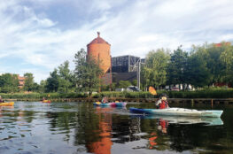
The lagoon would never fill again. Following the cleanup, the Estabrook Dam was also removed. After three-quarters of a century, the river once again flowed freely through Lincoln Park. Although motorboats no longer cruise the waters, with improved water quality it has become a paradise for paddling enthusiasts and anglers. The four islands remain in the park; their wetlands, shallow marshland, and wooded lowlands make them havens for wildlife. The park is also home to the dramatic 14-foot-tall, bright red Sea of the Ear by Japanese sculptor Takashi Soga.

Westabrook Trail’s Cement Lake
This narrow path runs north from Capitol Drive toward the wooded bluffs across the Milwaukee River from Estabrook Park. It’s designed as a “healing nature trail,” and the north end of the trail features sculptures that artist Tom Queoff created from remnants of the erstwhile Estabrook Dam.
But this strip of land also has a distinctive history. Beneath the UW-Milwaukee/Milwaukee Area Technical College remote parking lot along the trail was once was a body of water known as Cement Lake. Excavated by Milwaukee Cement and later abandoned, it and the neighboring Blue Hole became deep quarry lakes popular with swimmers in the early part of the 20th century, despite significant dangers. “Their sudden drop-offs, underwater ledges and submerged caves claimed many unwary swimmers,” Carl Swanson wrote in his Milwaukee Notebook blog in 2015. Cement Lake was filled with trash and other landfill from the 1930s to the ’50s; it’s now a parking lot. Blue Hole, a smaller pond so dangerous it earned the nickname “Suicide Hole,” remains along Westabrook Trail.
Gems of the Greenway: Estabrook Park
If the country’s largest producer of cement hadn’t gone bankrupt, there might be no Estabrook Park.
In 1873, Joseph R. Berthelet discovered that deposits of limestone near Estabrook Falls contained a heavy clay component that made it a natural hydraulic cement. An outcropping protruded from the earth near a low-lying meadow on the east bank of the river.
It was enough to convince Berthelet to start the Milwaukee Cement Co., which purchased the land and built a mill. Miners dug quarries and tunneled under the bluff to extract the limestone. (Sinkholes that developed in the park later have been attributed to the mining tunnels.)

The company grew, expanding its operations to the west side of the river, and in time became the nation’s largest producer of hydraulic cement. However, around the turn of the 20th century, new materials and techniques made the limestone source obsolete. Milwaukee Cement suspended production in 1911. The mills were burned, the kilns destroyed, and the land put up for sale. Milwaukee County purchased 83 acres and established the park in 1916, naming it after Charles E. Estabrook, a lawyer and politician who served on the Milwaukee County Park Commission. To a tourist camp that had previously existed were added athletic fields, picnic areas, paths, bridges and a bridle path. In 1927, Estabrook Parkway became the first of the series of recreational drives along Milwaukee County waterways.
The CCC worked in the park from 1934 to 1937, building paths, fence lines and the nine stone staircases that still lead from the top of the bluff to the river. This was also when the Estabrook Dam was constructed, which involved removing a 1,500-foot rock ledge on the river and creating a new channel. As a result, an island was created between the two constructed parts of the dam. Eventually the dam fell into disrepair and was removed in 2018. The island remains, as does the lagoon. The WPA also moved one of the oldest structures in Milwaukee – the 1844 Kilbourntown House, better known as the Benjamin Church House – to the park in 1938. The excellent, if modest, example of Greek Revival architecture can be toured on Sundays.

But Estabrook was not immune from the decline suffered by the entire valley as people turned away from the polluted river. Much of the park fell into disrepair. It wasn’t until the early 2000s that things began to improve. Friends of Estabrook Park helped Milwaukee County Parks protect the environment and enhance the quality of the park, rebuilding trails, planting native flora, rebuilding the nine staircases and more.
And then came the Estabrook Biergarten. Beer gardens have had a long and storied history along the river. Estabrook, however, never had one until 2013, when it opened the first free-standing beer garden in the country since Prohibition, the first in a series that followed in other Milwaukee County Parks. It was modeled on Munich’s biergärten in honor of Milwaukee’s German heritage. Once again, Estabrook Park became a destination.


Voices of the River

Joanna Demas, River Revitalization Foundation
The Greenway has many different meanings to me – it’s my office, my therapeutic sanctuary, one of my favorite places to recreate, my “backyard.” I love observing how the community interacts with it and watching folks building their own unique relationships with a natural space that is so dear to me. The Greenway is a dynamic place that is always engaging, whether it’s the sorts of people who are enjoying it, experiencing the seasons, or observing how the landscape changes from invasive
thickets to thriving lands of diverse flora and fauna.
Gems of the Greenway: Riverside Park
Of all the storied parks in the Greenway, Riverside has perhaps endured the most dramatic transformations. Once a popular Frederick Olmsted-designed jewel in the county park system, the neglect that beleaguered the entire upper river after increasing contamination made it repugnant was compounded here by a reputation for drug trafficking and violence. By the late 20th century, the park seemed like a lost cause, its hallowed pathways disused, degraded and overgrown. But you would never guess that as you walk around the park now.
Visitors to the resurgent and revitalized park would be hard-pressed to remember the grimmer aspects of its history – especially the tens of thousands of youngsters born after 1991 who have been among its most ardent users since the Urban Ecology Center was founded in that year. Established with the express intention of reducing crime and increasing the park’s appeal, the UEC quickly achieved success while growing into an innovative model of environmental education that attracts attention to Milwaukee from across the nation.

From humble beginnings in a trailer behind Riverside High School, the UEC has expanded, first into the award-winning, sustainable Riverside Park facility and subsequently into two additional branch locations. The UEC’s impact on Riverside Park goes well beyond its mission to foster ecological understanding and “connect people in cities to nature and each other.” It coordinates thousands of
volunteers annually to remove invasive species, plant native species, mitigate erosion, maintain trails and restore ecosystems that support wildlife.

As a consequence of the UEC’s efforts and programming, Riverside Park has become immensely popular once again, this time as an outdoor classroom and living laboratory where the city’s children, families and other residents come to learn about their natural environment.
If you cross from east to west, Riverside may seem like two parks; the Oak Leaf Trail divides the park’s 25.4 acres into two sides with distinct characters. The east side hosts a playground and athletic fields for the adjacent Riverside High School. A short stroll will take you past Milwaukee native Peter Flanary’s abstract sculpture Walk Like a River – three cage-like bronze forms that contain glacial stones. When you cross into the 15-acre woodland between the Oak Leaf Trail and the river, you will find a landscape much as it must have looked in 1889, now graced by stately, mature bur oaks and sugar maples. The latest transformation of Riverside Park is its incorporation into the 40-acre Milwaukee Rotary Centennial Arboretum, dedicated in 2013.


Voices of the River
Marin (Mark) Denning, Oneida/Menominee
The Menominee Nation has long been centered north of Milwaukee, but its people knew well the land at the confluence of the Milwaukee, Menomonee and Kinnickinnic rivers – a trade hub well before the arrival of French explorers and missionaries like Pere Marquette.
When newer settlers arrived, Native people were moved out by negotiation, force, guile and outright fraud. By the middle of the 19th century, the Native people who remained did so in small numbers with no officially recognized lands. We became effectively invisible to a growing and industrialized Milwaukee, our natural world destroyed, our ancestors’ bodies built over. Despite it all, Native Americans continued to live here quietly.
Then, with a shift away from manufacturing, the city slowly began to diversify. Natural Milwaukee has been reborn. After generations of environmental activism and work, sturgeon have returned to areas of the Milwaukee River long rendered uninhabitable for them. And as these fish have returned, so has the presence of Native American interests and practices related to water. Today, a Menominee group named Menīkānaehkem – Community Rebuilders from the Menominee Reservation – has sponsored tribal members to canoe the Milwaukee River.